Date
15.03.2026Start Time
09.30Start Location
The Hill Dickinson Stadium, Regent RoadEvent Information
Important information
Exciting Update: Fresh New Routes for the Liverpool Half Marathon & 10 Mile!
Thanks to planned works on Canada Boulevard, this year’s event is getting a fantastic refresh! We’re introducing a brand‑new route and a slightly later start time of 09:30 giving you an even smoother, more relaxed start to your race morning.
You’ll now set off from The Hill Dickinson Stadium and cross the finish line at the iconic Royal Albert Dock Liverpool, a perfect backdrop for those well‑earned finish‑line photos!
Your baggage will be securely transported from start to finish, so you can focus on enjoying every step of the journey.
Rest assured, the routes remain the same distance and still include all the much‑loved features that make this event special.
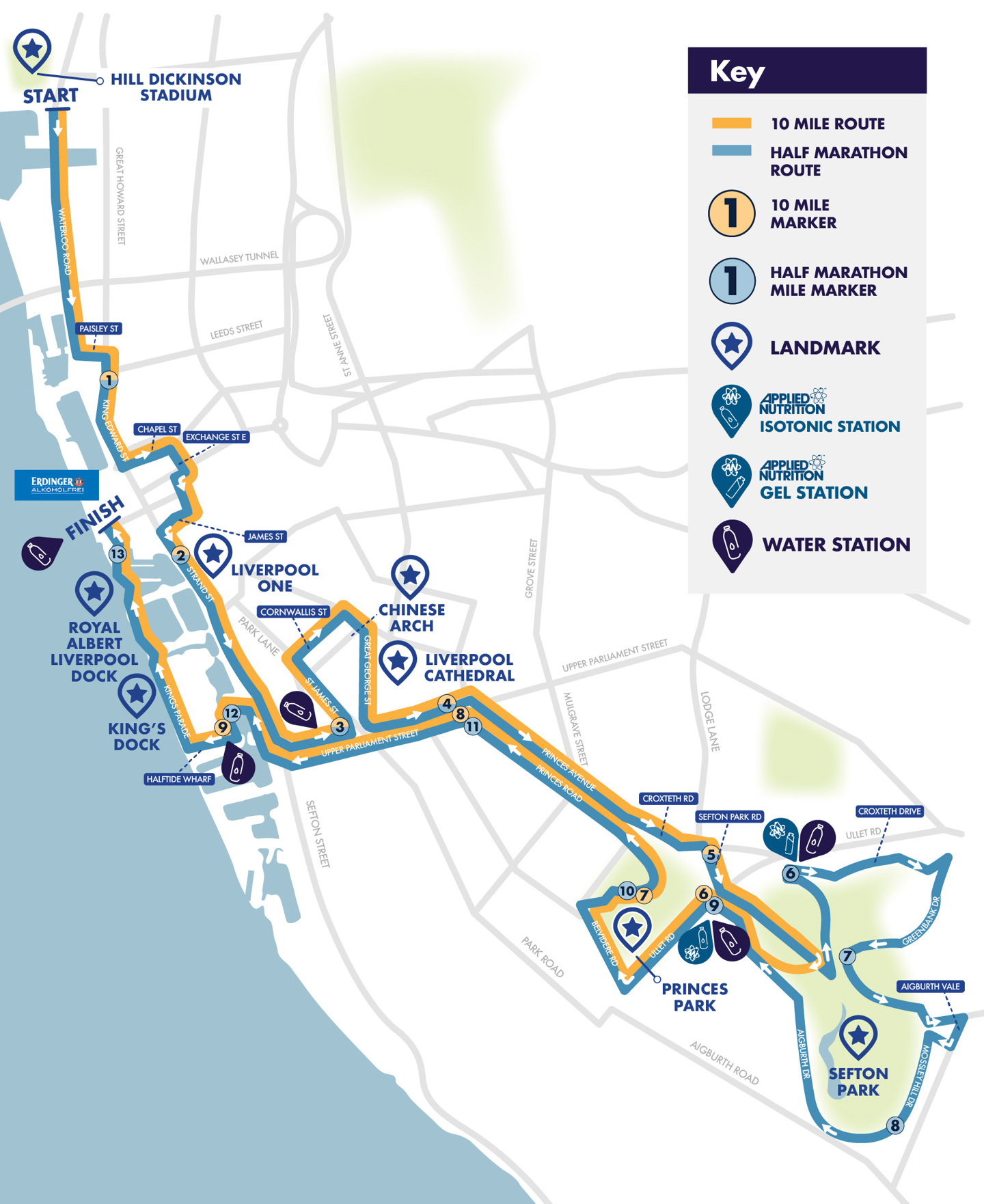
Take a moment to check out the updated routes below and plan your travel.
We can’t wait to cheer you on! 🎉
The race date for 2026 will be Sunday 15th March and entries are sold out.
The half marathon has become a firm favorite in the lead up to the London Marathon with many people using the race as a test of their progress as they head toward the tail end of their marathon training.
We are pleased to announce that the Northwest Air Ambulance Charity is our headline partner charity.
Others use the 10 mile distance as a step up from regular 10Ks and test themselves over a longer distance so there are plenty of reasons to take part in this celebratory event.
Either way it's a great way to see the city!
2026 marks the 32nd anniversary since the start of what was originally known as the Liverpool INTERNATIONAL Half Marathon back in 1994. And with the city now a firm visitor destination with people from across the world, the event equally certainly attracts runners from far and wide. It's set to be another fantastic day in Liverpool.
Entry
Entrants need to be 17 years or over.
What's Included
- Chip timing
- Finisher’s goody bag
- Finisher T-shirt
- Exclusive medal
- A fantastic experience!
Race Number Information
Entries outside the UK
If you are taking part and have a postal address outside mainland UK then you can collect your race number from the enquiry tent on race morning.
You will be emailed directly about this prior to the race date.
Race Day Gear

Official Merchandise
Get ready for race day with our official Liverpool Half Marathon merch! Explore the collection and gear up in style.
Shop the Official Race GearRoute
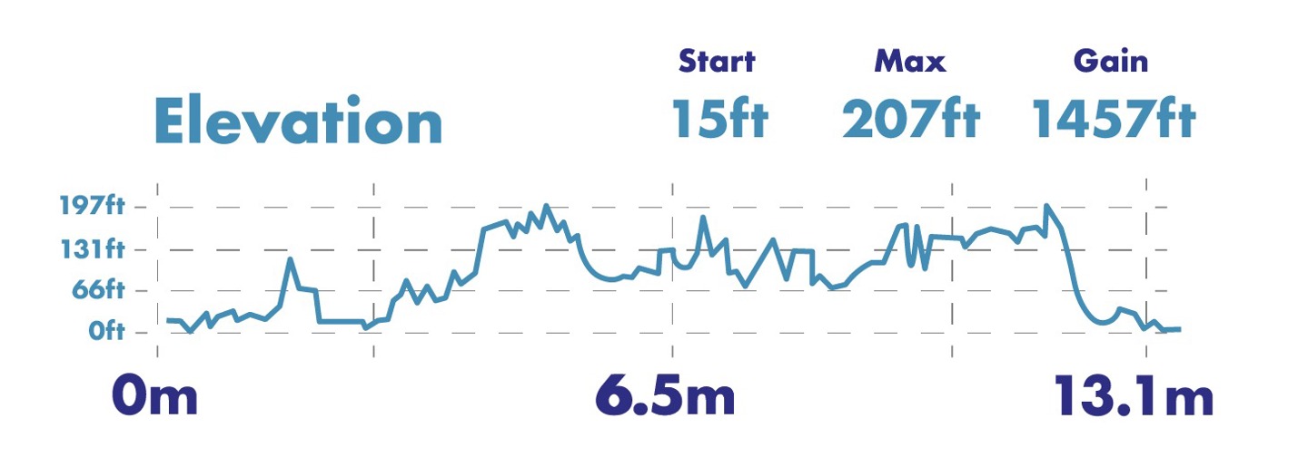
Elevation Map

Liverpool Half & 10 Mile Route Map

Interactive route map
Travel
The start line will be at The Hill Dickinson Stadium and finish line is at the Pier Head on the waterfront in front of the Liver Buildings in the city centre.
Nearest Station: Sandhills (Northern Line)
Northern Line trains run approximately every 30 minutes on Sundays, with typical arrival times including: 08:31 and 09:01
From Sandhills, it is a short walk or onward bus to the stadium area.
Connecting Services
Merseyrail trains on other lines will run to Liverpool Central or Moorfields, where passengers can change to Northern Line services for Sandhills.
Parking
The Hill Dickinson Stadium is approximately 1.4 miles (around 30 minutes on foot) from Liverpool City Centre.
Below are the main city centre car parks, including walking distances to the stadium:
|
Car Park |
Postcode |
Spaces |
Walk to Stadium |
|
Walter Street |
L5 9TP |
328 |
0.3 miles / 6 min |
|
Lanyork Road |
L3 7DB |
460 |
1 mile / 22 min |
|
Leeds Street |
L3 6BS |
300 |
1.2 miles / 28 min |
|
Pall Mall |
L3 6AL |
640 |
1 mile / 23 min |
|
Moorfields |
L2 2AY |
577 |
1.4 miles / 32 min |
|
Princes Dock |
L3 1DL |
760 |
1.1 miles / 24 min |
|
Capital MultiStorey |
L3 9DL |
895 |
1.3 miles / 29 min |
|
Liverpool ONE |
L1 8LT |
1,900 |
1.6 miles / 36 min |
|
John Lewis |
L1 8LJ |
581 |
1.8 miles / 40 min |
|
Kings Dock |
L3 4BX |
1,500 |
2.2 miles / 49 min |
|
Mount Pleasant |
L3 5TB |
1,535 |
2.2 miles / 50 min |
Additional Information
Road Closure Information
2026 Liverpool Half Marathon Road Closure PosterEvent Partners
Headline Partner Charity
The North West Air Ambulance Charity’s helicopters and critical care vehicles operate 365 days a year. Their highly skilled doctors and critical care paramedics on board provide enhanced pre-hospital care to patients across the entire North West region each year – an area covering 5,500 square miles and over 8 million people.
Since its launch in 1999, the North West Air Ambulance Charity has been called to over 45,000 missions across the region, an average of around seven times a day.
Just as the many critically ill and injured patients would not have survived without the service the charity provides; the North West Air Ambulance Charity would not be here without the support of its community of fundraisers and partners.
The charity is not part of the NHS and doesn’t receive any government funding. They rely completely on public and corporate donations to carry on saving lives. The North West Air Ambulance Charity must raise over £18 million every year to continue its lifesaving service.
Charity Places
wuth.charity@nhs.net
events@clairehouse.org.uk
FAQs
Yes, for more information please review our updated terms and conditions - Here
As the race is held under UKA License, the age limit for entries is 17 years on race day.
Yes you can. There is no obligation for you to do so as a condition of entry but you are welcome to fund raise if you wish.
Yes. Everyone who completes the course on the day will receive a medal and a technical T shirt.
Yes it is. As the event is staged under UKA License the course is accurate to 13.1 miles and has a UKA Course Measure Certificate confirming the accuracy of the course.
The closing date for entries is normally two weeks before race date. Entries will remain open for longer if numbers are available.
If entries are available during the last two weeks then the online facility will remain in place. If not it will clearly state ENTRIES CLOSED.
Entries will still be taken during the last two weeks (if available) but NOT posted out due to the inconsistent nature of Royal Mail deliveries.
If you enter during the last two weeks then you can collect your race pack in person from the event office or on race morning.
Normally there would be a time of 3 hours to complete the course but as the last four miles are off the public highway with runners returning along the promenade, it is not imposed. It should be noted however that the Marina access bridge at approximately 11.5 miles will be in operation from around midday to allow yacht craft out on the river. This may impede you if you have not crossed this location within 3 hours.
There is currently no plans to open entries into this event again. However, Liverpool Half Marathon entries are still available through the Partner Charities.


